Slight chance of rain in next 10 days?
Posted by Bret B  on March 8, 2015, 12:47 pm on March 8, 2015, 12:47 pm
187.148.141.155
Just in case anyone is planning roof work soon, I wanted to give a "heads-up". Normally March and April are rain-free for La Manzanilla. Actually the 10-years of data show no measurable rain for the 3-month span from mid-February to mid-May. But we've been having unusual weather patterns this year so far, as that rainy spell in February showed.
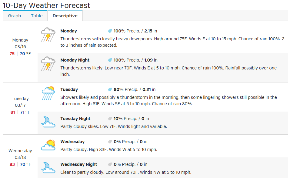
The Weather Underground forecast predicts significant rainfall next weekend (for Barra anyway): a little bit on Friday the 13th, then upwards of an inch over Sunday, Monday, Tuesday. They also show a slight chance tomorrow (Monday) night. As always, take a BIG grain of salt with any forecasts this far in advance: http://www.wunderground.com/q/locid:MXJO0760?
The Mexican ConAgua forecast predicts a chance of rain on Tuesday, but doesn't go out to next weekend yet: http://smn.cna.gob.mx/boletin/discusion/discusion.html
The normally-reliable GFS computer model predicts some significant accumulations (maybe 1 inch?) not too far from us in the inland mountains on Wednesday and Thursday, but not much during next weekend: http://www.hpc.ncep.noaa.gov/mike/gfs/crb_p24i_loop_12.html
I can't add much local guidance to these predictions yet. It's too early to be very sure, but I think it's worth crying wolf rather than getting a rude surprise while your palapa is torn down or whatever...
I'll keep you posted. |
------------------------Re: Slight chance of rain in next 10 days?
Posted by Neal on March 8, 2015, 5:21 pm, in reply to "Slight chance of rain in next 10 days?"
201.133.154.39------------------------Good Visual Link Bret!
Posted by daniel c on March 8, 2015, 8:38 pm, in reply to "Slight chance of rain in next 10 days?"
98.232.59.204------------------------Rain forecast: Monday update
Posted by Bret B on March 9, 2015, 9:28 am, in reply to "Slight chance of rain in next 10 days?"
187.148.141.155
Not much change in the forecast for next weekend (see 1st post.) Today however, the Weather Underground says we have a 50% chance of rain and even thunderstorms in the afternoon, with less than a tenth of an inch accumulation. I personally would cut that down to maybe 20%, based on my experience with their forecasts, and my other (meager) forecast resources. And I doubt there would be thunderstorms.
The GOES-West IR satellite loop does show a thick plume of high-level cloudiness currently streaming onshore to our north, and slowly edging southward toward us: http://www.ssd.noaa.gov/goes/west/epac/flash-avn.html
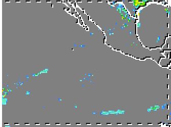
But high-level clouds don't always equal rain. The TRMM satellite shows actual precipitation as of a few hours ago. You can see there was very little rain coming out of the heavy yellow clouds shown in the IR loop: http://trmm.gsfc.nasa.gov/trmm_rain/americas/americas_3hrly_zoom.gif
0900Z TRMM data:
Until tomorrow...
|
------------------------Re: Chance of rain increasing for weekend
Posted by Bret B on March 10, 2015, 5:01 pm, in reply to "Slight chance of rain in next 10 days?"
187.148.141.155
Summary:
My forecast resources are converging more and more on the consensus that we will have a good chance of significant rains this weekend. This is most bizarre!
And not just computer models are getting crazy: on my drive up to Perula and back this morning, there were a few sprinkles. Then when I got home I saw this over the mountains not far to our east:
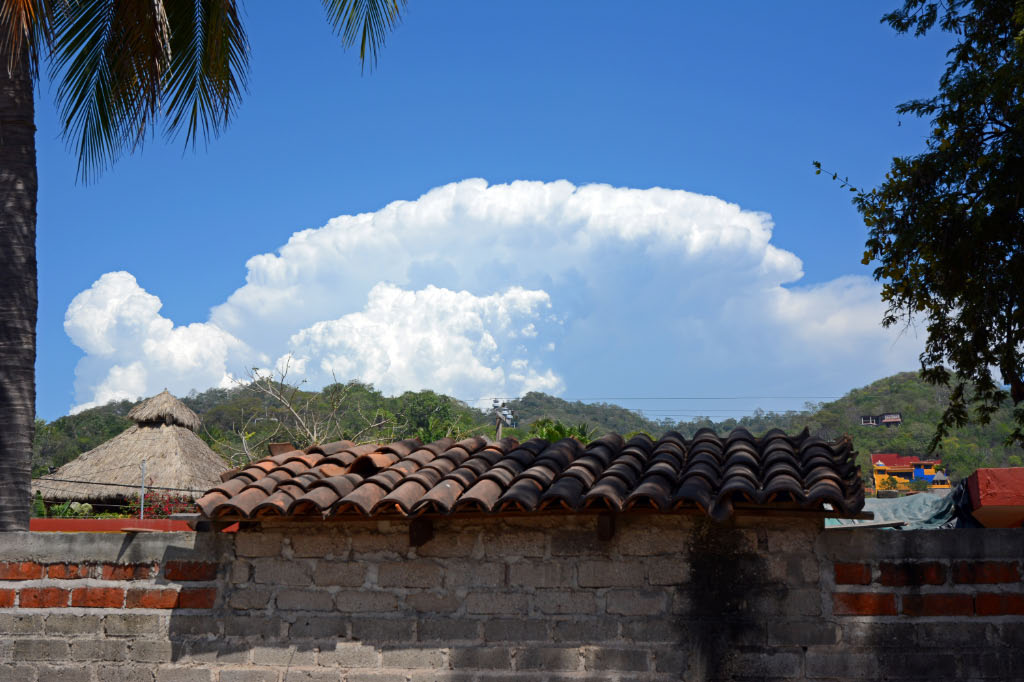
Thunderstorms in March? This is exactly what we see in June! (After a while these storms got sheared off and pushed inland. No rain for us, ALSO just like June.)
Details:
W.U. now says 50%-75% chance of rain Saturday, Sunday and Monday, with total 3-day accumulation of over 2" (!) http://www.wunderground.com/q/locid:MXJO0760?
CONAGUA says ( http://smn.cna.gob.mx/boletin/discusion/discusion.html ):
> Today (Tuesday): Parts of Jalisco get 1-2".
> Tomorrow (Wed): Parts of Jalisco have 60% chance of 0-1".
> Thur: nothing.
> Fri: 0-1" for somewhere in Jalisco.
> Sat: 1-3" for somewhere in Jalisco.
GFS computer model ( http://www.hpc.ncep.noaa.gov/mike/gfs/crb_p24i_loop_12.html ) shows a very heavy band of rains soaking the coast in Michoac�n and Colima Sat, Sun, Mon, with total 3-day accumulations above 4" in this band. We are close to the edge of the band, so if anything shifts it north very much we could get a few inches:
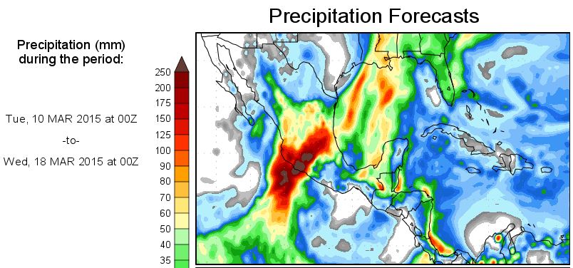
Here's another site to make you start building an ark. I check it frequently, but I don't know how accurate it is. We'll see: http://wxmaps.org/pix/prec3.html They predict a total accumulation over the next 7 days of about 4" for us, with peaks of 10" within a couple hundred miles of us (!!)
Possible causes:
The only mention I've found is in today's Tropical Weather Discussion for the East Pacific ( http://www.nhc.noaa.gov/text/refresh/MIATWDEP+shtml/ ): "MEANWHILE AN UPPER TROUGH REACHES FROM THE CENTRAL PLAINS THROUGH THE SOUTHERN ROCKIES OF THE U.S...THEN SOUTHWARD ALONG
105W AND OFF THE CENTRAL MEXICAN COAST. AN AREA OF ASSOCIATED SHOWERS AND THUNDERSTORMS IS ACTIVE ONSHORE OVER JALISCO STATE IN MEXICO NEAR THE BASE OF THIS TROUGH...BUT WITH NO SIGNIFICANT
WEATHER NOTED OFFSHORE. GLOBAL MODELS INDICATE AN UPPER LOW WILL CUT OFF OVER THE SOUTHERN TIP OF BAJA CALIFORNIA FRI AND SAT. ALONG WITH INCREASED MOISTURE THIS WILL ALLOW INCREASED CHANCES
FOR SHOWERS AND THUNDERSTORMS ALONG THE MEXICAN COAST NEAR MANZANILLO LATE IN THE WEEK."
I'll try to keep you posted...
|
------------------------Re: Chance of rain increasing for weekend
Posted by David Dagoli on March 10, 2015, 5:22 pm, in reply to "Re: Chance of rain increasing for weekend"
187.148.40.85
Weather Channel:
|
------------------------Re: Chance of rain increasing for weekend
Posted by Daniel H on March 10, 2015, 8:21 pm, in reply to "Re: Chance of rain increasing for weekend"
201.133.153.237
Right or wrong Bret, your the go to meteorologist in my opinion,
I trust you more than my cat!  .... I mean your more consitient .... I mean your more consitient
than Tequila  I mean...oh hell, you know what I mean. I mean...oh hell, you know what I mean.
Thank you. |
------------------------Re: Chance of rain increasing for weekend
Posted by Jane G on March 10, 2015, 8:30 pm, in reply to "Re: Chance of rain increasing for weekend"
189.164.205.209------------------------Re: Chance of rain increasing for weekend - hailstorms inland yesterday!
Posted by Bret B on March 11, 2015, 8:51 am, in reply to "Re: Chance of rain increasing for weekend"
187.148.141.155
Some of those thunderstorms we saw to our east yesterday afternoon (among others farther inland according to the IR loop yesterday) dropped a lot of hail in the higher locations. Here is a screen grab from http://canal235.com/ showing 2-3" of hail on the highway near Tapalpa (a pretty little town in the mountains southwest of Guadalajara):
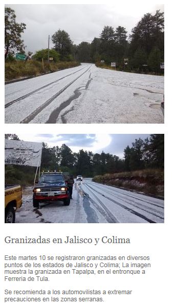
Its getting more and more like June (except the temperature...)
|
------------------------Re: Chance of rain increasing for weekend - hailstorms inland yesterday!
Posted by DanH on March 11, 2015, 11:18 am, in reply to "Re: Chance of rain increasing for weekend - hailstorms inland yesterday!"
173.255.183.16
We got 0.8 inches of rain in Ajijic yesterday afternoon and evening. Everyone is shaking their heads, no one can remember March rain here.
Since we're headed to La Manz on Sunday for a week be advised that no rain will be permitted from Sunday to Sunday there. :>)
Thank you for you cooperation! |
------------------------Re: Chance of rain increasing for weekend - hailstorms inland yesterday!
Posted by Tim Edwards on March 11, 2015, 2:35 pm, in reply to "Re: Chance of rain increasing for weekend - hailstorms inland yesterday!"
198.0.232.53------------------------Re: Rainy weekend - Thursday update
Posted by Bret B on March 12, 2015, 8:04 am, in reply to "Re: Chance of rain increasing for weekend"
187.148.141.155
It's amazing how little all the predictions have changed in the last few days. We are still going to get at least a little wet, and maybe an inch or two.
The changes since my last update ( http://members5.boardhost.com/lamanzanilla/msg/1426028513.html ) are:
> W.U. now shows the rain stretching into Tuesday and maybe even Wednesday, and a little less total accumulation:
http://www.wunderground.com/q/locid:MXJO0760?MR=1
> CONAGUA agrees mostly.
> GFS model is about the same.
> Wxmaps.org is about the same.
> NHC Trop Wx Discussion is about the same: "THE MODELS THEN DEPICT A STRONGER MID/UPPER LEVEL LOW THAT CUT-OFFS OVER THE SOUTHERN GULF OF CALIFORNIA ON SAT...AND MEANDERS IN THAT AREA THROUGH SUN. ITS POSSIBLE THAT DEEP LAYERED SOUTHERLY FLOW COUPLED WITH INCREASING PRECIPITABLE WATER VALUES OF 2 INCHES OR MORE COULD SET THE STAGE FOR POTENTIALLY HEAVY RAINFALL LATE IN THE WEEKEND ALONG THE COAST OF MEXICO FROM MANZANILLO TO PUERTO ANGEL."
Welcome to weird weather! At this rate, the jungle might not ever drop its leaves and turn brown this "dry season". If March is looking like June (except for the heat,) what will June look like?? |
------------------------June Will Be Wonderful
Posted by Mark S. on March 12, 2015, 8:47 am, in reply to "Re: Rainy weekend - Thursday update"
189.164.205.104
We'll have temp. and humidity in the 90s, the ocean will warm, the streets will be vacant and the house fans will be humming.
My only concern is Hwy. 200: if it's this bad now, I dread how much more it will deteriorate. |
------------------------Re: Slight chance of rain in next 10 days?
Posted by Vicki and Robin on March 12, 2015, 9:28 am, in reply to "Slight chance of rain in next 10 days?"
187.148.186.195
Whether it's cold
Or whether it's hot,
We will have weather,
Whether or not.
|
------------------------Re: Slight chance of rain in next 10 days?
Posted by Rhema on March 12, 2015, 12:24 pm, in reply to "Re: Slight chance of rain in next 10 days?"
189.164.205.119|
Or as my Dad used to say, "Everyone always talks about the weather but no one ever does anything about it". |
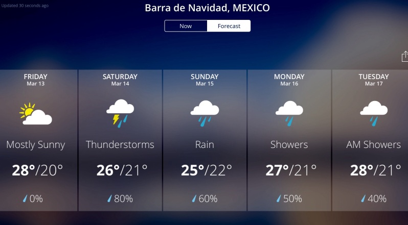
------------------------Friday update: even heavier rain forecsat?
Posted by Bret B on March 13, 2015, 8:50 am, in reply to "Slight chance of rain in next 10 days?"
187.148.141.155
Summary:
Not much change in likelihood and timing of the online rain forecasts for this weekend (25-50% chance on Sat, then near-100% chance on Sun, Mon, Tue.) But it looks like the total accumulations are predicted to be heavier than yesterday's forecasts, and sliding more into Tuesday.
Details:
> W.U. now forecasts OVER 5 INCHES total accumulation for the whole 4-day period:
http://www.wunderground.com/q/locid:MXJO0760?MR=1
> CONAGUA predicts even more: SOMEWHERE in Jalisco gets 0-1" today, 3-6" Sat, 3-6" Sun, 2-3" Mon:
http://smn.cna.gob.mx/boletin/discusion/discusion.html
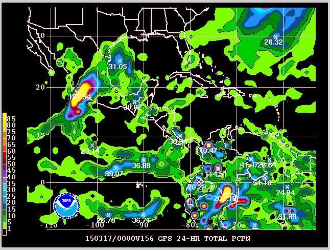
Here's their 4-day graphical forecast (yes, it's this tiny on their site also!) I circled our vicinity in red on the 1st map. You can see the "cut-off mid- and upper-level low pressure feature ("eighth winter storm") settling in to our northwest that is to blame for sweeping that thick band of moisture from the Pacific (blue arrows) over the western Mexico coastline:
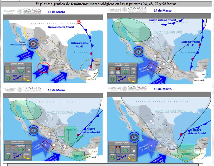
But the computer models shown on the CONAGUA site don't really support this much rain in Jalisco. The WRF-SNM and GFS both show most of the rain staying to our south: http://smn.cna.gob.mx/index.php?option=com_content&view=article&id=16&Itemid=87
>The 7-day GFS model ( http://www.hpc.ncep.noaa.gov/mike/gfs/crb_p24i_loop_12.html ) also shows the heavier rains staying just to our south in Colima and Michoac�n. Then on Tuesday it shows us getting a couple or three inches.
My opinion:
I think the various models don't support multi-inch rainfall for La Manzanilla, especially when we have seen in the past how these heavy Pacific moisture plumes tend to drop most of their rain just before crossing the coast, and then they resume heavy rains inland over the higher terrain. We seem to have a localized "coastal effect" that the models don't include very well.
So my forecast: high chance of rain later this weekend, but more like 1-2" total. But keep in mind it would only take a 50-100 mile shift northwards of the heavy rain band to greatly increase our accumulation (6-8-10 inches worst-case.)
Get your laundry hung and your roofs finished today to be safe!
Until tomorrow... |
------------------------Re: Friday update: even heavier rain forecsat?
Posted by Julie and Rusty on March 13, 2015, 9:56 am, in reply to "Friday update: even heavier rain forecsat?"
201.138.176.22
Every time I look at the forecast they increase the amount of expected rain!!!
There goes our road again!!!
CRAZY! |
------------------------Re: Friday update: even heavier rain forecsat?
Posted by Larry F on March 13, 2015, 11:02 am, in reply to "Re: Friday update: even heavier rain forecsat?"
189.164.250.10|
Ah, but Julie, it will be snowing on the east coast on Sunday. Not that that eases the pain of watching your road flow down the hill once again. |
------------------------Re: Friday update: even heavier rain forecsat?
Posted by David Dagoli on March 13, 2015, 11:20 am, in reply to "Re: Friday update: even heavier rain forecsat?"
187.148.40.85------------------------Re: Friday update: even heavier rain forecsat?
Posted by Daniel H on March 13, 2015, 11:33 am, in reply to "Re: Friday update: even heavier rain forecsat?"
Edited by board administrator March 13, 2015, 11:39 am
Usually when a rain prediction happens one can look at a weather loop and see
the rain coming. When I do that now I see nothing coming at all.  |
------------------------Sat update: no big change
Posted by Bret B on March 14, 2015, 8:41 am, in reply to "Slight chance of rain in next 10 days?"
187.148.141.155
Today's chance of rain went down some (I predict maybe 20% chance of measurable rain by tonight.) Plenty of cloudiness today though. Tomorrow (Sun) and Mon are well over 50% in my opinion, but I still think the W.U. and CONAGUA storm totals are too high for La Manz. I'd say more like 1-2" through Monday night. Tuesday might be pretty rainy also, but that's a little too far for my crystal ball to reach yet.
I still have to caution that we will be right on the edge of a zone of some very high rainfall amounts, so there is a slight chance our 1-2" could go as high as 6-10".
The people to our south (Melaque, Barra, Cihuatlan, Manzanillo) will have more and more rain than us, so heads-up if you are travelling that way tomorrow or Monday (including airport departures.) And the "pothole forecast" for our local stretch of Highway 200 is for many severe holes hiding under the rainy road surface, and multiplying terribly because of the rain. I'm not kidding: in the rain, that drive will be hazardous to your vehicle and your safety; go slow and be careful!
Sorry, no more spiffy screen grabs and links today. Not much different from yesterday's... |
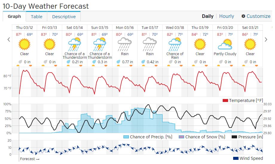
------------------------Sun update: "firehose" turning our way later today?
Posted by Bret B on March 15, 2015, 9:58 am, in reply to "Slight chance of rain in next 10 days?"
187.148.141.155
We just got our first sprinkle of the weekend, but there's quite a bit more coming according to the forecast sites and computer models. The raw computer models are gradually agreeing with the Weather Underground forecast, so I have to agree that we should expect around 4" total through Tuesday.
Just keep in mind that there is a large uncertainty caused by being so close to the sharply defined edge of the "firehose" that is currently soaking Michoac�n and Colima. Our actuals could be a little as 1" or as much as 10" (those extreme totals are showing in all the models, within 100 miles of La Manz.)
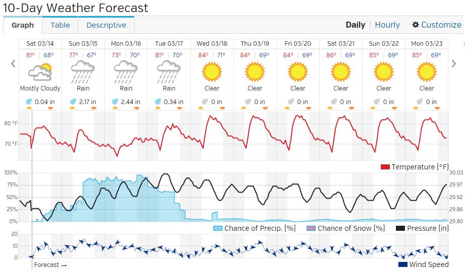
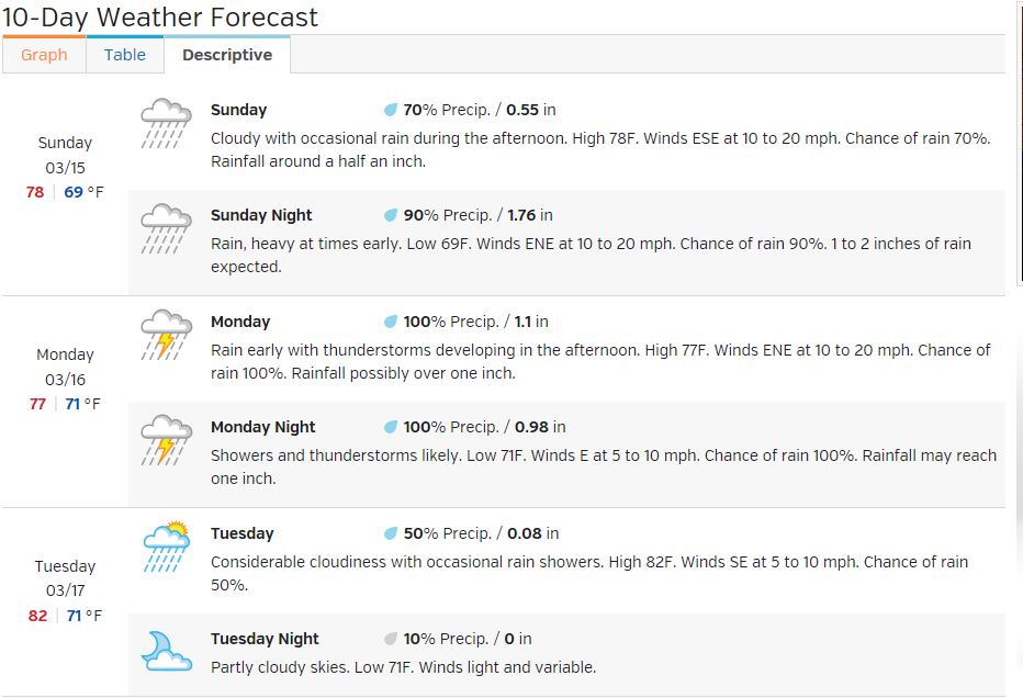
W.U. forecast: ( http://www.wunderground.com/q/locid:MXJO0760? )
The IR loop shows the "firehose" quite well:
http://www.ssd.noaa.gov/goes/west/epac/flash-avn.html
And here is the more zoomed-in view from CONAGUA (don't forget to refresh this animated GIF every time you look at it):
http://smn.cna.gob.mx/satelite/goesE/co/loop.gif
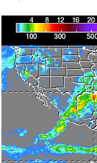
The IR loops show the center of the firehose well south in Michoac�n, but the TRMM satellite data shows that the actual falling rain is mostly in the northern side of the firehose, so "loops can be deceiving..."
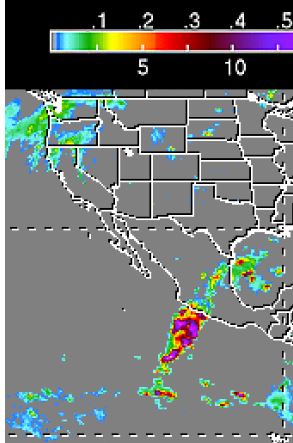
TRMM near-realtime rainfall from a few hours ago shows some of the heaviest and widest rainfall rates hitting the coast that I have ever seen, including the last few years of hurricanes. Up to 0.5"/hr sustained rate, which is very heavy by TRMM standards, was centered on northern Michoac�n, as far as I can tell: http://trmm.gsfc.nasa.gov/trmm_rain/americas/americas_3hrly_zoom.gif
The TRMM 7-day accumulation ( http://trmm.gsfc.nasa.gov/trmm_rain/americas/americas_accumulation_zoom.gif ) shows 6-8" has ALREADY fallen onshore near the Colima/Michoac�n border:
I wouldn't be surprised to hear reports of flash flooding and mudslides in the hardest-hosed areas. Forget June; welcome to September weather (minus the heat!)
Stay tuned for more updates if anything changes... |
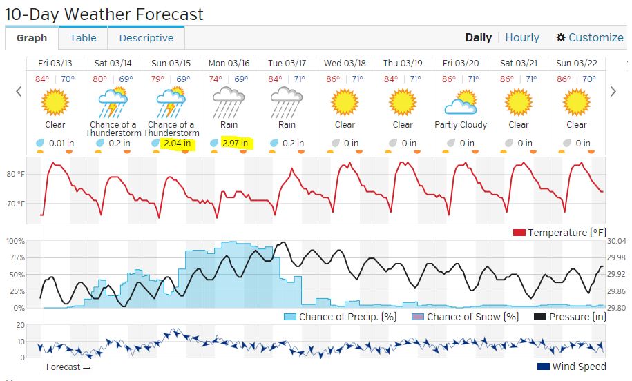
------------------------Mon.rain totals.
Posted by Bret B on March 16, 2015, 8:32 am, in reply to "Slight chance of rain in next 10 days?"
187.148.43.133
Well. it's time to throw out the micro-detailed analyses and board your arks. You DID make your arks didn't you?
Yesterday we got 3.0" / 76mm by bedtime.
Since then we got 4.0" / 102mm until 7:30 am today.
Storm total 7.0" / 178mm (and counting.)
I already had to put out a deeper rain gauge / bucket!
This would be pretty heavy weather even in the rainy season. For March, it's CRAZY.
I hope everyone is staying safe.
The W.U. forecast for today shows 3", but we ALREADY got more than that!
http://www.wunderground.com/q/locid:MXJO0760
I think we have a good chance of hitting my "worst-case" number of 10" for the total storm accumulation.
Here's a good story about our "March firehose" storm from Accuweather: http://www.accuweather.com/en/weather-news/mexico-flooding-weekend-mudsli/43721977
I don't have any rain reports from other nearby stations. Melaque/Barra not yet, Manzanillo airport has no functional rain gauge, The only Personal Weather Station remaining in Manzanillo also has no rain gauge, and of course there is no weather radar in this part of Mexico.
Later...
|
------------------------Re: Mon.rain totals.
Posted by Ron Smith on March 16, 2015, 9:00 am, in reply to "Mon.rain totals."
187.148.142.193|
At about 6:30a while I was still pretending to sleep I counted lightning flashes over a 5 minute time period. They were from 9 to 14 seconds apart, with 11 seconds being the most frequent interval. Amazing. |
------------------------Re: Mon.rain totals.
Posted by lisa Fern on March 16, 2015, 9:20 am, in reply to "Mon.rain totals."
187.148.42.197
Oh Bret, the weather wizard,
Why is it so cold?
When is it going to stop raining?
(I only have 1 dry towel left)
Amazingly, haven't lost power for any length of time, although maybe I should keep quiet about that!
Thanks! |
------------------------Re: Mon.rain totals.
Posted by Larry F on March 16, 2015, 9:28 am, in reply to "Re: Mon.rain totals."
189.164.203.235
Hey, Bret, I didn't build an ark but I did move my old ark, the car, down the road to drier ground. This morning the cars who didn't move are up to their floor boards in mud. I'll later to see what animals moved into it.
Calle Concha Molida is washed out, barely walkable in places.
Question of the week - Which local businessman will be the busiest over the next week? |
------------------------Re: Mon.rain totals.
Posted by Daniel H on March 16, 2015, 9:34 am, in reply to "Re: Mon.rain totals."
189.164.217.49
Answer to question of the week - Real Estate offices. Everyone will be
buying back downhill what used to be theirs uphill, mainly roads and driveways. |
------------------------Re: Mon.rain totals.
Posted by Bret B on March 16, 2015, 10:45 am, in reply to "Re: Mon.rain totals."
187.148.43.133
OOO, OOO, pick me! Pick me! Would this mystery businessman drive a big yellow maquina?
What do I win? A complimentary Right Now Weather � report from Mark? |
------------------------Re: Mon.rain totals.
Posted by Bret B on March 16, 2015, 10:39 am, in reply to "Re: Mon.rain totals."
187.148.43.133
Hi Lisa, the cold is normal when it rains for a long time (lots of rain cooling the air plus no sun to warm it up.) Even in the summer it can get pretty cool in our drafty house by day 2 or 3 of a slow pass-by of a hurricane. Right now it's 69.7�F at my back yard. During hurricane pass-bys I haven't seen less than 70�F.
Of course if the wind comes up then you have some wind chill to deal with...
Sometime today the rain should start tapering off and be done by late tomorrow. It's taking a break right now, but I'm pretty sure we are not done with rain today yet.
Those frequent power outages like last last night happen often in the summer also. A small battery back-up (UPS) for my computer is really handy then to have time to check the weather and stay in touch via the message board. You need to plug your Telmex modem into the UPS also. Luckily the local Telmex building here in La Manz that splits out all of our DSL lines has a good battery bank and/or generator. Even during Hurricane Jova in 2011, the Telmex DSL service stayed up for over 24 hrs of our 33-hr power outage. |
------------------------Re: Mon.rain totals.
Posted by Larry F on March 16, 2015, 12:02 pm, in reply to "Re: Mon.rain totals."
189.164.203.235
Bret wins the prize ..... yes, big, yellow, noisy. It moves the real estate from down the hill back up the hill to the original owners. Sorry, Daniel.
The prize is a pass for white water rafting through the lagoon overflow. It is the world's only white water river rafting with a crocodile feature. Way cool! |
------------------------Re: Mon.rain totals.
Posted by DanH on March 16, 2015, 1:13 pm, in reply to "Re: Mon.rain totals."
187.148.142.124
I should have taken you seriously when you said to print the picture of the sun and paste it to the top of my umbrella.
Unfortunately, we weren't even smart enough to bring the umbrella.
Drat! |
------------------------Re: Mon.rain totals.
Posted by julieandrusty on March 16, 2015, 2:50 pm, in reply to "Re: Mon.rain totals."
173.254.198.163
My gauge is now up to well over 10 inches in about 24 hours.
Heard the road to PV is closed, but the Manzanillo airport road is fine. Lots of small land slides on the road to Melaque with major holes that will swallow your car. Be very careful!
There is a hole in the road around from the Galeria that a bus could fit in "AGAIN".
Not your typical March weather!!
|
------------------------Re: Mon.rain totals.
Posted by Ron Smith on March 16, 2015, 3:26 pm, in reply to "Re: Mon.rain totals."
187.148.142.193
My friend Chelino and I just dug my car out from the runoff deposited behind the church. I certainly mis-judged that.
I'm just glad that I didn't try to park at the top of the hill at Brisa del Mar last night. I was somehow able to overcome the force of testosterone then. |
------------------------Re: Slight chance of rain in next 10 days?
Posted by Daniel H on March 16, 2015, 4:05 pm, in reply to "Slight chance of rain in next 10 days?"
189.164.217.49
Hi Bret,
Well this has to be a big feather in the cap of weather prediction, so
far in advance (your first post was on the 8th which was 9 days ago!)
and pretty much right on!
I did some checking (not much, this is mostly me being lazy) but don't really
understand what it was that made this such a predicable event?
Another question is how in the watery hell is all of that moisture coming
out of such a concentrated area? Is there any water left there at all? |
------------------------Re: Slight chance of rain in next 10 days?
Posted by Vicki and Robin on March 16, 2015, 4:13 pm, in reply to "Re: Slight chance of rain in next 10 days?"
201.138.181.188
I love the title of this thread!  |
------------------------Re: Slight chance of rain in next 10 days?
Posted by Pat L. on March 16, 2015, 5:06 pm, in reply to "Re: Slight chance of rain in next 10 days?"
Perhaps the end is in sight?? What say you, weather guru?
|
------------------------ What hit you!
Posted by daniel c on March 16, 2015, 7:58 pm, in reply to "Slight chance of rain in next 10 days?"
98.232.59.204------------------------Post mortem (?) storm report and new records
Posted by Bret B on March 17, 2015, 1:43 pm, in reply to "Slight chance of rain in next 10 days?"
187.148.43.133
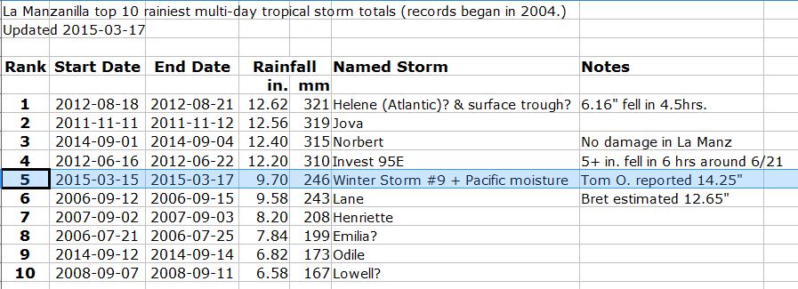
(I just have time for a quick report right now. More later.) I thought the Mexican CONAGUA site was calling this low pressure system "Tormenta Invernal #8" (winter storm #8), but it was apparently #9. Just trying to give it a name for our record books. I dub thee "Winter Storm #9."
Briefly, my forecast resources say there is still a small chance of rain today, tapering off to nothing by tonight. I'll address the longer-range forecast later, but tomorrow at least looks pretty dry.
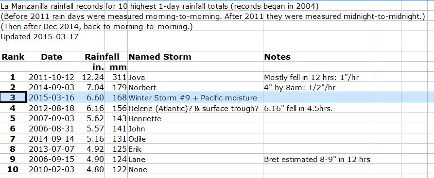
Total rain over the 3 days here at my back yard was 9.7" / 246mm, but others around town have reported as much as 14.25" / 362mm. Amazing! I can't explain the wide variation, but I'll include these other reports as side notes in my weather data spreadsheet. Thanks for the reports!
The first sprinkles came Sunday morning around 9am, but the first measurable rain didn't start until mid-day Sunday I believe.
We set one record for sure: yesterday's maximum (NOT minimum) temperature was the coldest in my 10-year record: 70.3�F / 21.3�C. During the whole day the temp didn't vary more than 1 degree F! Here is a list of the top 8 coldest max temps:
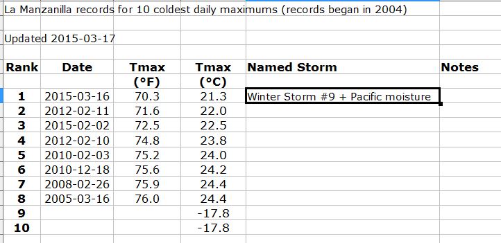
This storm came in #5 in the top 10 wettest multi-day storms in the last 10 years (it would have been #1 if we used the 14.25" from Tom O.):
And it came in #3 in the Top 10 1-day rain totals (probably would have been #1 here also using Tom's numbers.):
And of course this was the record-wettest March. Our data shows no measurable rain in March back to 2004. Betty U. reports that she is sure there has been no rain in March back to 1995. And my Mexican neighbor who grew up here also remembers no rain in March at least back into the '80s. Pretty loud way to introduce March to it's first rain!
Enjoy the sun! More to come...
|
------------------------Re: Post mortem (?) storm report and new records
Posted by Claude G on March 17, 2015, 5:41 pm, in reply to "Post mortem (?) storm report and new records"
This 2015 9 Winter storm at Pueblo Careyes produced:
synday 11 am to monday 11 am, 11".3
For the total, sunday 11 am to thueday 11 am 14".69
Claude |
------------------------Re: Post mortem (?) storm report and new records
Posted by Bret B on March 17, 2015, 6:06 pm, in reply to "Re: Post mortem (?) storm report and new records"
187.148.43.133|
Thanks for the report, Claude. I'll add it into my records. |
------------------------Re: Post mortem storm report and new records
Posted by Bret B on March 18, 2015, 8:08 am, in reply to "Re: Post mortem (?) storm report and new records"
187.148.43.133
A minor correction to my Top 10 list of multi-day rainfall records: the dates for Hurricane Jova were wrong. They should say 2011-10-11&12, not 2011-11-11&12.
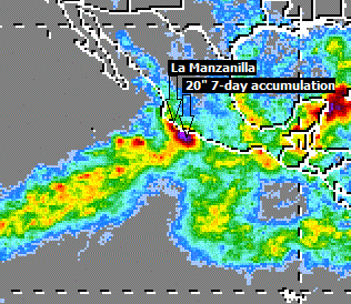
Another interesting post-mortem graphic is the TRMM satellite's 7-day rain accumulation: http://trmm.gsfc.nasa.gov/trmm_rain/americas/americas_accumulation_zoom.gif
The resolution is just barely good enough to see that we had plenty of yellowish storm totals around us (about 6" / 150mm), and a few red spots not far away (about 10" / 250mm.) That's fairly good correlation with our locally-measured "ground truth."
One effect that was missing is the usual "coast effect" that I've seen in most if not all TRMM data for cyclone-related storm totals. This effect is a very noticeable decrease in the heavy rains right along the coast. The heavy rains are offshore a few dozen miles, but much less at the coast. So I learned not to extrapolate this effect to a winter storm! Here's an example from 2012-06-23:
In the case of our Winter Storm #9, it was interesting to see how well the Weather Underground predicted the timing of the storm, even 8-9 days in advance. I don't know why they did so well this time. Usually the over-predict heavily for La Manz. Their predicted rainfall amounts were about 2x low, but better than mine (5-10x too low!)
I still have some learning to do... |
------------------------Thankyou Brett
Posted by Rob Boyes on March 17, 2015, 7:48 pm, in reply to "Slight chance of rain in next 10 days?"
187.148.41.140|
Thanks Brett , for the well presented weather data. I , for one, appreciate the effort put into your posts. ( see "slight chance of rain thread) A lot of questions answered to my satisfaction. Keep up the good work, please. |
------------------------
[ La Manzanilla Message Board ]
|
|
|
|
|
|
|
|
|
|
|
|
|
|
|
|
|
|
|
|
|
|
|
|
|
|
|
|
|
|
|
|
|
|
|
|
|
|
|
|
|
|