TS Marty: heavy rain threat to Mexican coast
Posted by Bret B  on September 27, 2015, 10:22 am on September 27, 2015, 10:22 am
70.190.168.128
Here's a heads-up before I go offline again in a few days. Tropical Storm Marty earned its name just last night, and is threatening a large section of the Pacific coast of Mexico with heavy rains because of its large size and slow movement. La Manz is not in the direct path, but this one is being hard to predict.
A Tropical Storm Watch has been issued for the coast as far north as Lazaro Cardenas (in the southern part of Michoacán.)
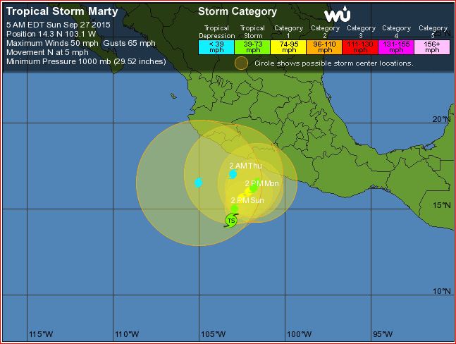
From the Public Advisory ( http://www.wunderground.com/hurricane/eastern-pacific/2015/Tropical-Storm-Marty?text=public&MR=1 ) (note the heavy rainfall predictions at the end):
"A tropical storm watch is in effect for...
* Acapulco, Mexico to Lazaro Cardenas, Mexico
A tropical storm watch means that tropical storm conditions are possible within the watch area, generally within 48 hours.
Discussion and 48-hour outlook
------------------------------
at 1000 am CDT (1500 utc), the center of Tropical Storm Marty was located near latitude 14.9 north, longitude 102.8 west. Marty is moving toward the north-northeast near 7 mph (11 km/h). A turn toward the northeast and a decrease in forward speed are expected tonight and Monday. On the forecast track, the center of Marty is forecast to approach but remain offshore the southwestern coast of Mexico.
Maximum sustained winds are near 60 mph (95 km/h) with higher gusts. Strengthening is expected during the next 24 hours, and could become a hurricane by tonight. Weakening is expected to begin Monday night.
Tropical storm force winds extend outward up to 80 miles (130 km) mainly to the east of the center.
Hazards affecting land
----------------------
wind: tropical storm conditions are possible within the watch area by Monday night.
Rainfall: Marty is expected to produce rainfall amounts of 4 to 6 inches with isolated maximum amounts of up to 10 inches across the Mexican state of Guerrero through Tuesday. These rains are expected to produce life-threatening flash floods and mudslides, especially in areas of mountainous terrain."
-----------------------------------------------
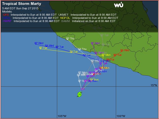
Here is the 5-day track prediction: note the large error circles; the center can be anywhere in those circles.
http://www.wunderground.com/hurricane/eastern-pacific/2015/Tropical-Storm-Marty?map=5day
Here are the various computer models: not much agreement after Monday/Tuesday:
http://www.wunderground.com/hurricane/eastern-pacific/2015/Tropical-Storm-Marty?map=model
Keep an eye on Marty. I might not be able to post any more reports.
PS, this time of year the storm tracks start to become erratic and hard to predict, and prone to making sudden right turns into the coast (like Jova in October 2011...)
|
------------------------Re: TS Marty: heavy rain threat to Mexican coast
Posted by Bret B on September 28, 2015, 9:10 am, in reply to "TS Marty: heavy rain threat to Mexican coast"
70.190.168.128
Not much change in Marty's forecast: still a heavy rainmaker for parts of the coast and a very uncertain track forecast. The Public Advisory has almost doubled the rainfall accumulation forecast for Guerrero:
"Marty is expected to produce rainfall amounts of 6 to 12 inches over the Mexican state of Guerrero through Thursday, with isolated amounts near 20 inches from the Sierra Madre del Sur mountains toward the coast. These rains are expected to produce life-threatening flash floods and mud slides, especially in areas of mountainous terrain."
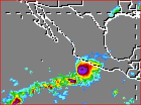
This is the most forecast rain I have ever seen from the NHC. However, it looks like the heaviest rains are currently heading toward Michoacán, not Guerrero. The huge blob is already visible in the Mexican IR loop:
http://smn.cna.gob.mx/satelite/goesE/co/loop.gif
And here is the latest snapshot from the TRMM site ( http://trmm.gsfc.nasa.gov/trmm_rain/americas/americas_3hrly_zoom.gif ):
I might not be able to post any more updates. Just use these links or your own favorites to keep an eye on Marty.
|
------------------------Re: TS Marty: heavy rain threat to Mexican coast
Posted by Mary Jo on September 28, 2015, 9:29 am, in reply to "TS Marty: heavy rain threat to Mexican coast"
189.164.202.178|
Thanks Brett for doing this work! Good to hear from you! |
------------------------Re: TS Marty: heavy rain threat dissipating
Posted by Bret B on September 29, 2015, 10:37 pm, in reply to "Re: TS Marty: heavy rain threat to Mexican coast"
70.190.168.128
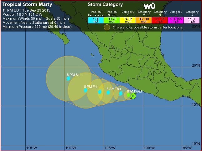
Marty suddenly straightened up and is now heading up the usual storm track well offshore, as it dissipates. Not much threat to La Manz anymore. Hopefully it didn't cause too much flooding in Guerrero.
Excerpt from Weather Undergound's blog by Bob Henson and Jeff Masters ( http://www.wunderground.com/blog/JeffMasters/comment.html?entrynum=3130 ):
"After a 12-hour stint overnight as a Category 1 hurricane, Tropical Storm Marty weakened to a tropical storm with top winds of 60 mph at 11 am EDT Tuesday. Radar images out of Acapulco show that Marty continues to bring heavy rain showers to the coast, and as of 8 am EDT Tuesday, the heaviest 24-hour rains along the coast were in the 3 - 3.5" range. With high wind shear of 30 knots now affecting Marty, continued weakening is likely. Marty may have made its closest approach to the coast, as steering currents are now lining up to drive Marty to the west, away from the coast, beginning on Wednesday morning. Given that Marty is a small storm that is weakening and likely to begin moving away from the coast soon, Mexico should be able to avoid widespread destructive flooding from the storm."
http://www.wunderground.com/hurricane/eastern-pacific/2015/Tropical-Storm-Marty?map=5day
Catch you later! |
------------------------
[ La Manzanilla Message Board ]
|
|
|
|